
Get ready Canada, because the arrival of El Niño could shake things up this summer.
After almost three years of La Niña, a pattern that's affected conditions across North America and led to some tumultuous hurricane seasons in the Atlantic basin, we might finally see a reversal of the pattern with a potential El Niño developing in the eastern Pacific Ocean.
But what does this mean for our weather? Brace yourselves, because this change could have a significant impact on the upcoming summer patterns across the country.

The National Oceanic and Atmospheric Administration's (NOAA) Climate Prediction Center (CPC) has issued an El Niño Watch as part of its April ENSO outlook. According to the NOAA, even a slight bump in water temperatures thousands of kilometres away could mean big changes for Canada's weather.
A watch is issued when conditions are favourable for the development of El Niño within the next six months. "While we are still in an ENSO-neutral phase – when no El Niño or La Niña is present – there is a 62% chance El Niño will develop sometime between May and July. This comes after nearly two continuous years of a La Niña," reads the outlook from the NOAA.
According to The Weather Network, El Niño and La Niña both describe periods of prolonged water temperature anomalies in the eastern Pacific Ocean around the equator.
"These anomalies can be as small as 0.5°C warmer than normal (El Niño) or cooler than normal (La Niña), but the trend has to last for about seven consecutive months in order to achieve that special milestone," reads a summer weather report from The Weather Network.
Forecasters predict that we could be headed straight into an El Niño next. According to the CPC, the odds of El Niño conditions setting in by this summer are greater than 50%, with a six-in-ten chance of it being in full bloom during the peak of hurricane season in late summer and early fall. Although the shift in sea surface temperatures might seem slight, it could have a significant impact on weather patterns worldwide.
So, how quickly will conditions flip? That's the key to unlocking the full extent of the impact.
As forecasters keep a close eye on the unusually warm water in the Pacific, they're turning to past El Niño events for hints on what we can expect for temperature and precipitation patterns in Canada in the months to come.
Although each event is unique, past data can provide valuable clues for the months ahead. Currently, we stand at a crossroads with two possible outcomes. The first scenario is a sudden leap from La Niña to El Niño, while the second is a gradual transition, according to The Weather Network.
A sudden shift could lead to cooler temperatures during the summer months for many Canadians. However, if we experience an early and swift El Niño this summer, it may mean a more comfortable season for all.
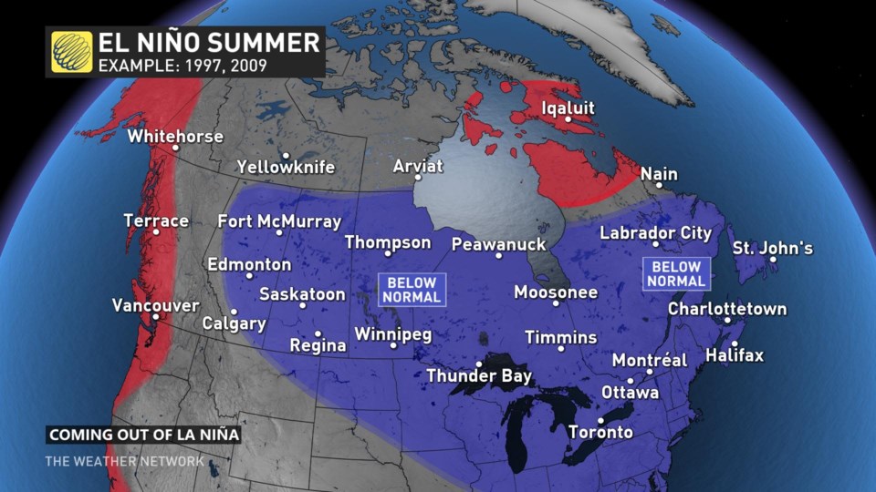
According to The Weather Network, "previous summers that saw El Niño conditions begin not long after La Niña conditions ended were cooler than normal for much of the eastern half of the country. The summers of 1997 and 2009 were examples of this sudden switch."
Those summers saw below-seasonal temperatures for just about everybody east of the Rockies, while folks along the immediate West Coast and in parts of the territories contended with above-seasonal temperatures.
While it's possible that we may experience an El Niño this summer, there's also a chance that we may enter a prolonged period of "neutral" conditions.
During this period, water temperatures in the eastern Pacific would remain around average for the season. If neutral conditions persist and gradually transition into El Niño later in the summer, we could see a different weather scenario across Canada. In this scenario, the impacts of La Niña could linger into the summer months.
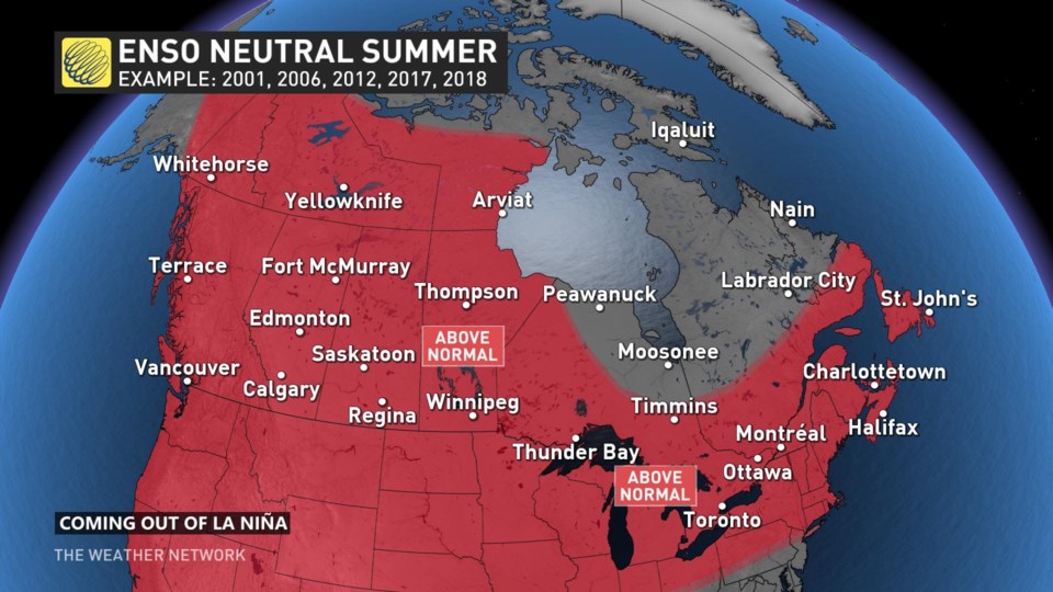
If you're hoping to avoid a hot summer this year, it's important to note that previous years with similar patterns include 2012, 2017, and 2018. These were seasons where above-seasonal temperatures were experienced across the entire country. If the current trend continues, we may see a repeat of these past patterns.
However, it's important to keep in mind that each season is unique and unpredictable, and weather patterns can change quickly. So, while we can look to the past for clues, only time will tell what kind of summer we can expect this year.


